|
Geography StudyCards Stacks - Countries, States, and Lists
|
|
FILE INFORMATION
This file is in a directory that is not included in ranking.
|
geostacks.zip
|
|
Filename
|
geostacks.zip (Download)
|
|
Title
|
Geography StudyCards Stacks - Countries, States, and Lists
|
|
Description
|
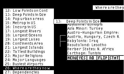
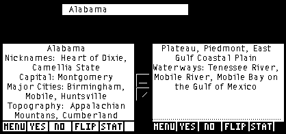
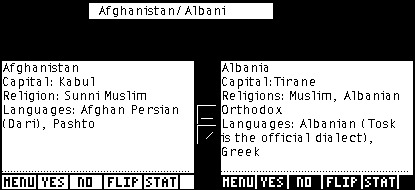
These three stacks cover information about 193 countries, 50 states, and many top lists covering geographical information. The countries studycards have the capital(s), religion(s), and language(s) of each country. The states studycards have nickname(s), capitals, major cities, topography and waterways. The 27 lists are many lists of leasts, mosts, largests, smallests, highests, lowests, and more.
|
|
Author
|
Michael White (mikewhite314@gmail.com)
|
|
Category
|
TI-83/84 Plus Flash Application Variables (StudyCards)
|
|
File Size
|
18,512 bytes
|
|
File Date and Time
|
Wed Mar 2 23:43:06 2005
|
|
Documentation Included?
|
Yes
|
|
Source Code Included?
|
No
|
|
SCREEN SHOTS
REVIEWS
There are no reviews for this file.
LEAVE FEEDBACK
Questions, comments, and problems regarding the file itself should be sent directly to the author(s) listed above.
Write a review for this file (requires a free account)
Report inappropriate or miscategorized file (requires an account; or you may email us directly)
If you have downloaded and tried this program, please rate it on the scale below
ARCHIVE CONTENTS
|
Archive Contents
|
|
Name
|
Size
|
| COUNTRY.8XV | 26032 |
| STATES.8XV | 15543 |
| LISTS.8XV | 6898 |
| readme.txt | 1425 |
|
|
|
|
|